
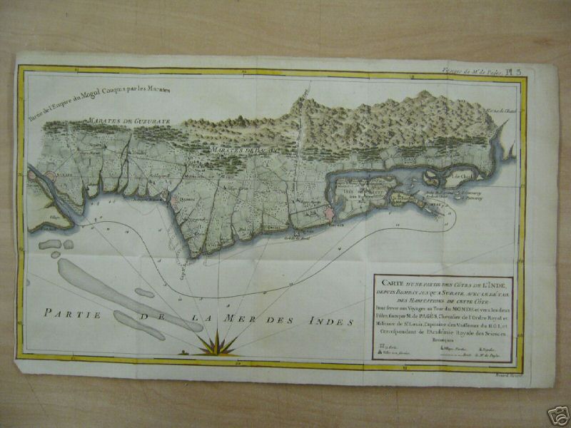
Map of Port and Island of Bombay with the adjacent islands, 1724
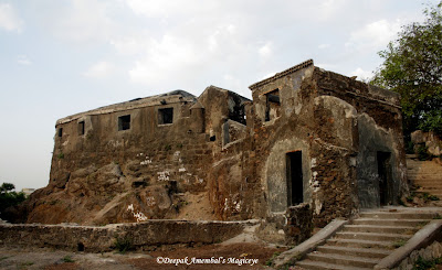
The Sion Hillock Fort is a fort in Bombay, India. It was built by the British Governor of Bombay Gerard Aungier atop a conical hillock. The hillock is situated a few metres from the Sion railway station. Sion was the boundary between British-held Parel island and Portuguese held Salsette Island and the castle marked the northeast boundary of their possession. The fort was built between 1669 and 1677.

![[Sion Fort 2]](https://lh3.googleusercontent.com/blogger_img_proxy/AEn0k_vBeTShLF2z8VI1QLbaWzM02J4Aw-rqB3l8nkM61RSB2nP9nQTd-1HTRh-Rr0BYqLvCUttEwCdqfS5dYCzB8hrtZsz4zcHFe97DdVfG9IID5E1xwt8P1UlEZEp05cSgWkPF2rHKyxZvJ63h=s0-d) Sion Fort - guardian of Bombay Island | Tok
Sion Fort - guardian of Bombay Island | Tok
WALES, James (1747-1795)
View from Sion Fort
Used with permission from the Peter Anker Collection held in the Kulturhistorisk Museum at the University of Oslo, Norway.
Plate 11: View from Sion Fort, 1791-1792.
In this second Plate [No. 11] James Wales provides an alternative panoramic view from the Sion Fort. From the vantage of Sion Fort, the view opens out to the island of Mahim. In this scene the walls of the fort dominate the foreground, with the curving line of the ramparts and an imposing cannon mounted in the battlement wall. The rising staircase and buildings behind the gun carriage are surmounted by a flagstaff asserting British sovereignty over the island. In other versions of this Plate there is no flag suspended on the flagstaff, so its inclusion here is an intriguing anomaly [cf: coloured etching held by Yale Center for British Art, listed as Plate 11, dated 1800, London].
The figures descending the stairs provide an ironic yet humorous counterpoint to the scene. There is the stout portly figure of an English military official whose waist is bursting from his red uniform, clearly the figure of a buffoon. He is accompanied by a European woman whose hand he holds; behind them follow two figures, one of whom is a woman carrying a small child. The status of these other women is unclear. The companion is clearly a figure of affection, while the woman in blue is presumably a nanny or wetnurse to the child. A one-legged, one-armed sepoy veteran stands waiting to greet the group, thereby highlighting the additional use of the fort as a sepoy hospital or hospice for military veterans. Once again the flat lands below the fort stretch into the indeterminate distance under a wide dominating sky. There are buildings and plantation areas with associated coconut palms in the middle distance, as well as thick clusters of native trees. On the far right of the picture, though significantly trimmed in this versio, is a pagoda, tomb or sati pavilion.
BELOW:-
The original Sion Fort was built between 1669 and 1677 by the second British governor of Bombay, Gerard Aungier (c1635-1677), on top of a conical hillock, and it marked the northeast boundary between the British-held Parel Island and Portuguese-held Salsette Island.
Macquarie Connection
Lachlan Macquarie recorded in his journal on 5 October 1789 that he had visited Sion:
Plate 10: View from Sion Fort, 1791-1792.
James Wales prepared two views of Bombay and its environs from within the walls of Sion Fort. In this first Plate [No. 10] there is a panoramic view over the islands and saltpans of the Bombay archipelago. The view looks down from the Sion Fort gate to Bombay and the Neat's Tongue, bounded by the Mahratta Mountains. James Wales infuses the scene with strong domestic setting, depicting a squatting Indian sepoy (possibly smoking a bhang pipe), with his wife nursing a baby, a small child, dog, and two bullocks (for pulling a two-wheel carriage) in a courtyard outside their modest dwelling beside the fort ramparts. The coastline and horizon are barely distinguishable in the suffused light, though in the middle distance the scene is punctured by the distinctive silhouettes of the coconut palms.The original Sion Fort was built between 1669 and 1677 by the second British governor of Bombay, Gerard Aungier (c1635-1677), on top of a conical hillock, and it marked the northeast boundary between the British-held Parel Island and Portuguese-held Salsette Island.
Macquarie Connection
Lachlan Macquarie recorded in his journal on 5 October 1789 that he had visited Sion:
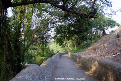
I went upon a very pleasant Party today, along with Col. and Mrs. Stirling, and Mr. and Mrs. Herring, and a number of Gentlemen, to Meham, [sic] and Sion Fort, where we dined and spent a very agreeable day; From the Fort on Sion Hill, which commands a most extensive view, we had a most charming Prospect of every part of the Island of Bombay, the neighbouring Islands, and Continent, which along with the variety of breaks of water intervening, forms a most beautiful and very Picturesque Scene; Sion Fort is Nine Measured Miles from Bombay Fort and is one of the Extremities of the Island, – being divided only by a very narrow channel from the large Island of Salcet, [sic] belonging also to the Presidency of Bombay. —
I travelled to Sion in a Palanquin, having Eight Bearers – a very easy and comfortable mode of Travelling in this Country. — We all returned in the Evening to Bombay. —"

View from Sion fort towards east in Bombay in 1815
Courtesy British library
This is plate 10 from James Wales' 'Bombay Views'. The series was painted for Sir Charles Malet (1752-1815), the British Resident of Poona, who Wales met in Bombay in 1791
This is plate 10 from James Wales' 'Bombay Views'. The series was painted for Sir Charles Malet (1752-1815), the British Resident of Poona, who Wales met in Bombay in 1791
his hillock is situated a few metres east of the Sion railway station.
Sion was the boundary between British-held Parel island and Portuguese held Salsette Island and the fort marked the northeast boundary of their possession.


Map of Port and Island of Bombay with the adjacent islands, 1724
1526 -Bombay--naval fight between Gujerat sultan's fleet and Portuguese navy from Colaba via Sion to Bandra
But the Portuguese had stationed boats at Bandra, and all Alishah's vessels but seven were taken. Of the seventy-three prizes thirty-three were fit for work and were kept; the rest were burned. Besides the vessels many prisoners were made, and much artillery and abundance of ammunition were taken. [Feria in Kerr's Voyages, VI. 209, 210. This summary of Faria's account of the battle of Bombay seems to differ in some particulars from the account in De Barros.' Asia (Decada, IV. Part I. 208-210,Lisbon Ed. of 1777). According to De Barros the Portuguese caught sight of the Gujarat fleet off a promontory. As Sylyeira drew near, the Gujrat fleet retired behind the promontory, and he sent some ships to guard the mouth of the river.
the Mahim church and Mithi river estuary ;[THE SEA EXTENDED FROM MAHIM-WEST COAST TO SION -EAST] COAST

When Sylveira drew near, the Gujarat ships set sail and ran into the river, and when they found that the mouth of the river was occupied, they tried to reach Mahim fort, but, before they reached Mahim, they were surrounded and captured by the Portuguese boats which had been sent to, guard the mouth of the creek. This account is not altogether clear. Apparently what happened was that when the Gujrat boats saw the Portuguese, they drew back from the Prongs Point into the Bombay harbour, and when the Portuguese fleet attacked them, they fled up the harbour to the mouth of the river (that is the Bombay harbour or east mouth of the Mahim creek) not daring to try their fortune is the open sea.'

The Portuguese captain learned from his local pilots that the Gujarat fleet probably meant to retreat through the Bandra creek, and accordingly sent boats to guard its mouth. The Gujarat fleet entered the creek by Sion, and, on nearing Mahim, saw the Portuguese boats blocking the entrance of the creek.

ABOVE-The Strait Between the Islands of Bombay and Salsette from a Portuguese Church Bandra, India-(The place of the naval war)
To avoid them they made for the Musalman fort of Mahim, at the south end of the present Bandra causeway, but the Portuguese saw their object and coming up the creek cut them off,
De Barros' account has been supposed ('Lateen' in Times of India, 21st April 1882) to favour the view that the fight was not in the harbour, but in the open sea off Malabar point. To this view the objection are, that when the Gujarat fleet retired behind Colaba point on catching sight of the Portuguese, they must have gone into Back Bay a dangerous and unlikely movement. That if they came out again to fight, they must have seen the Portuguese boats being sent on to Bandra, and that when, in their flight, the Gujarat fleet found the mouth of the Bandra creek blocked, they could not have attempted to take shelter in Mahim.

map I574 shows BOMBAY AS ISLANDS

BELOW:-MAP OF BOMBAY 1672


\BANDRA FORT
the attempt to take shelter in Mahim, when the mouth of the creek was found to be blocked, shows that the Gujarat fleet was leaving not entering the Bandra or Mahim river.]
SEWRI FORT 17TH CENTURY BELOW

View of Bombay in 1773[view from colaba island towards Bombay fort.the church and fort walls can be seen]

View Of Bombay, From Mazagon Hill.

 The seven islands of Bombay were an
archipelago of islands that were, over a span of five centuries,
connected to form the area of the modern city of Mumbai. The seven
islands were gradually physically united through land reclamation
projects. The original archipelago was composed of the following
islands:
The seven islands of Bombay were an
archipelago of islands that were, over a span of five centuries,
connected to form the area of the modern city of Mumbai. The seven
islands were gradually physically united through land reclamation
projects. The original archipelago was composed of the following
islands:1.Isle of Bombay,
2.Colaba
3.Old Woman’s Island (Little Colaba)
4.Mahim
5.Mazagaon
6.Parel
6.Worli
It took over 150 years to join the original seven islands of Mumbai. These seven islands were lush green thickly wooded, and dotted with 22 hills, with the Arabian Sea washing through them at high tide.
The original island of Mumbai was only 24 km long and 4 km wide from Dongri to Malabar Hill (at its broadest point) and the other six were Colaba, Old Woman’s island, Mahim, Parel, Worli, Mazgaon.
Reclamation:
i) First Phase of Reclamation:
Surat administration ordered to undertake reclamations as early as 1698; factory records relate small beginnings, but major works were not begun until 1710, when the breaches in the north were closed to the tidal waters of Mahim bay and Creek, to be followed by the closing of the breaches between Worli and Mahim, and still later the Hornby Vellard.
The seven islands of Bombay when they originally came in the hands of the British from the Portuguese, included Colaba, Old Women’s Island, Bombay, Mazgoan, Parel-Sewree-sion, Mahim and Worli. They were then separated by narrow creeks which could be crossed over during low tide. Therefore, between 1784 and 1845 four raised causeways were constructed which welded together these disjoined islands.
1. Hornby Vellard (1784) at Mahalaxmi united Cumballa Hill with Worli;
2. Duncan Causeway (1803) joined Sion with Kurla (Salsette);
3. Colaba Causeway linked Bombay with the two Colaba islands;
4. Mahim Causeway (1845) joined Mahim with Bandra.
ii) Second Phase of Reclamation:
This phase consisted of all the smaller reclamations taken place within the city. It was executing the smaller schemes and strengthening of the island from within. It was the implementation of smaller plans of schemes like Nagpada scheme, Frere Estate, Mody bay Estate, Ballard Estate etc.
iii) Third Phase of reclamation:
The 3rd phase of Reclamations was the most controversial of the projects, the one launched by the Back Bay Reclamation Company which came into being in 1863. Fortunately, before the company came to an abrupt end it had reclaimed a precious strip of land west of Queens Road (Maharishi Karve Road). Later, the Public Works Department stepped in, committees and schemes proliferated, feeding on and in turn fed by controversy.
MAP OF ISLAND OF BOMBAY-1893

 History of Bombay under British rule - Wikiwand
No comments:
Post a Comment